The natural scenery of the Sundarbans is beautiful and the natural mineral and biological resources always attract people. Sundarbans is the richest place in biological resource of the country. The highest biodiversity of the country can be found in this region. It is the largest mangrove forest in the world Sundarbans is also famous for its natural beauty. Each year lots of people come here to view the beautiful places of the Sundarban. The number of tourist increases each year the natural beauty of Sundarban has impressed us. We visited the different tourist spots in Khulna region. The natural beauty of Sundarbans, the rivers, the animals all over the fear of the great Royal Bengal make our tour full of excitement.
SUNDARBANS
Friday, May 16, 2008
Subscribe to:
Posts (Atom)
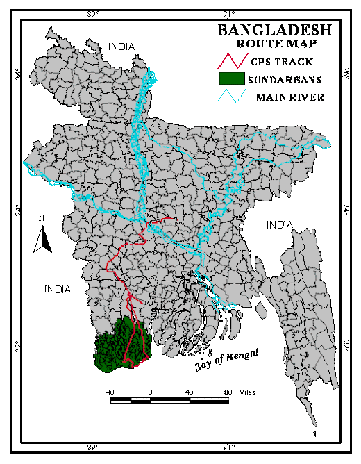
ROUTE MAP JU TO SUNDARBANS
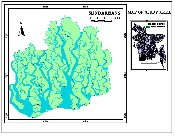
STUDY AREA
Kachikhali
Location and accessibility
Kachikhali is at eastern side of Katka.It belongs to Sundarban East Wildlife Sanctuary under Sundarban East Forest Division and about 14 Km away from Katka. Transportation system from Khulna/ Mongla is similar to Katka.
Existing Fauna
The following fauna are available in kachikhali-
· crocodiles,
· deers
· lizards
· wild boar and
· Lots of birds etc.
Flora
The prominent species in Kachikhali are Sundari (Heritiera fomes) and Gewa (Excoecaria agallocha).. Almost all mangrove plant species are evergreen, dwarf, shrubby or tall treesThere is a thick mat of the nipa palm or 'Golpata' (Nipa fruticans) by the side of almost all the canals.There also have Goran (Ceriops decandra), Keora (Sonneratia apetala), Ora (S. caseolaris), Passur (Xylocarpus mekongensis), Dhundul (X. granatum), Bain (Avicennia alba, A. marina, A. officinales), and other rhizophores, and Hantal (Phoenix pelludosa) etc.
Kachikhali
Katka
Katka is one of the most attractive spot of Sundarban. It is famous for deer, tiger, crocodile, verities birds and monkey, morning and evening symphony of wild fowls.
Absolute location of Katka
Katka is located between 21˚51′23" N latitude and between 89˚ 46′ 35"E longitudes.
Relative location
Katka is situated at the southern part of Bagerhat district. Kochikhali ecopark is situated in north-eastern part of Katka. Sharankhola range in north and Bay of Bengal in southern side of Katka.
Katka
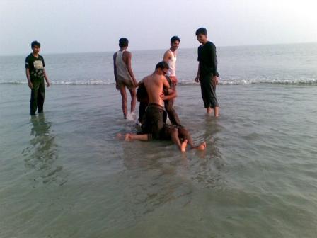
Badamtali Sea Beach at Katka
Dublar Char
Location
Dublar Char is the Southern part of Khulna district. This island is the marginal part from Bay of Bengal. Passur River flows eastern side of this island. Shibsha River has flows western side & after river Hiron point is located.
Absolute Location
Lat: 21° 56′ 48.3′′ N
Long: 89° 48′ 39.8′′ E
Dublar Char is a beautiful island where herds of spotted deer are often seen to graze. Dublar Char is an island with a beautiful beach. The other attraction of the island is the fishing activities that take place every year between mid-October and mid-February. Fishermen from other places of the country, especially from Chittagong, assemble here during the period to catch fish and dry them on the sunny beach. The honey collectors go into the forests during April-May.
Dublar Char
Hiron Point
Location
Absolute location
Latitude: 21º 45′ N.
Longitude: 89º 25′ E.
Relative location
Hiron point is the southern part Sundaban and khulna district. It is surrounded by water bodies in the three sides .The Bay of Bengal is situated in the southern side. The khulna Range lies in the north.
The Orpan Gachia River lies in the west and the Poshur River in the east. The Putni Island is situated near the south west part of Hiron point.
Description
Hiron point is famous for Royal Bengal Tiger, Deer , Monkeys, Crocodiles, Birds , natural beauties .It is the meeting place of Bay of Bengal and Sundarban. To enjoy the high waves of sea and the natural beauty of Sundarban one should visit the Hiron point .There are two rest houses in Hiron point .One is for forest department and other is for the authority. For the rent the rest houses advance booking should be given to the forest department. There are two VIP Cabin, 11 room, and a large hall room .Almost 70to 80 people can stay there comfortably .The rent varies for the government non government tourists.Some information of willed life and others: Nilkamal wild life sanctuary (hironpoint).
Area
Forest area (land): Almost 41685.0 hectors.
Khals and rivers: Almost 175600 .0 hectors.
Total 577285.0 hector.
Vegetation
Halophytic in natural , the major plant species are Sundary ,Gewa, Poshur , keora , Bean , kankre, Dhundol, Golpata, Goran, Hindal, Sirgra , khalsi, Bhola , etc.
Fauna
The following fauna are found at that area-
a. Mammal: Royal Bengal Tiger, Spotted deer, Braking deer , Willed, Boar, other surd, Rhesus monkey, Bottle headed, Dolphins etc .
b. Common Reptiles: Estuarine, Crocodile, Pythons, Lizards, Flap shelled, Spotted truths etc.
c. Common fish and Crustacean: Beelike, Passas, Hilsha, Reka, Pangas, Rita,Salmon, Catfish, etc. Later Shrim, Prawn is caught and is being exported.
d.Aves: Pon, Hiron, fishing, Eagle, Cattle, Egret, Red jangle poul etc.
Hiron Point
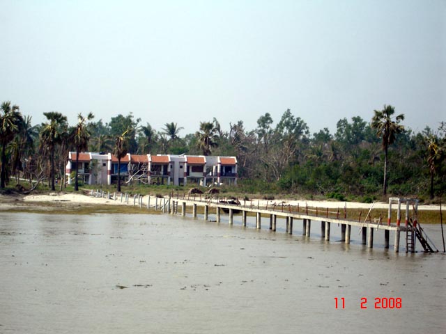
Karamjal
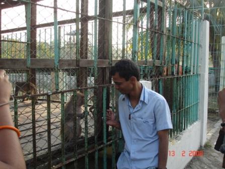
Karamjol is a forest station for the Rangers. Here you can see a dear breeding center. To visit Sundarban you need to go there with a guide and it is even better if you go there with a group. You can stay two/three days in Sundarbans depending on your desire and requirements. One-day tour is not enough for Sundarban as you will not be able to see the nature in haste. For one-day tour you can go up to Karamjol and at a glance visit the outer portion of Sundarban forest areas. In your Sundarban tour you will be able to see a lots of verities birds (a heaven for the bird watchers), can watch the fishing in the river by the fishermen, if you wish you can ask your tour operator to give a stopover in the fishermen villages to watch their lifestyle, see lots of animals like monkeys, various types Dears, foxes, Crocodiles, Snakes and if you are lucky person you will be able to see the greatest mystery of Sundarban –The Royal Bengal Tiger. Sundarban is one of main sources to collect pure honey.
Flora
1.Passur: Xyclocarpus mekongeneis
Family: Meliqceqe
Type of plant: Medium tree
Uses: Timber used for furniture & building materials.
2. Hargoza: Acanthus ilieifolius
Family: Acanthaceae
Type of plant:Thony shrub
Uses: Fruit pulp is used as a blood purifier & leaf past is used in rheumatism.
3.Tiger Fern: Acrostichum aureum
Family: Pteridiaceae
Type of plant: Gregarious fern.
4. Avicennia Officinalis
5. Kankara: Bruguiera gymnorhiza
Family: Rhizophoraceae
Type of plant: small to medium tree
Uses: Its hard wood stems is used in building.Fishing ,boats,houses,poles & for charcoal making & extracting tonria.
6. Shingara: Cynometra ramiflora
Family: Leguminosae
Type of plant: Shrub or small tree
Uses: Fuel woodpiles & row materials of hard bord.
7. Amur: Amoora cucullata
Family: Meliacue
Type of plant: Small tree
Uses: People & fuel wood.
8. Gewa: Excoecaria agallocha
Family: Euphorbiaceae
Type of plant:Medium tree
Uses: Wood is used in making pape pulp match wood border & in soft wood.
9. Bhola: Hibicus tiliqce us
Family: Malvceae
Type of plant: Shrub
Uses: Fuel wood & facing materials.
10. Sundari: Heritiera fomer
Family: Sterouliaceae
Type of plant: Tall tree
Karamjal
ASSESSING THE IMPACT OF CYCLONE SIDR IN COASTAL PART OF BANGLADESH
Cyclone Sidr is the fourth named storm of the 2007 North Indian Ocean cyclone season. The storm formed in the central Bay of Bengal, and quickly strengthened to reach peak sustained winds of 215 km/h (135 mp/h), which would make it a Category-4 equivalent tropical cyclone on the Saffir-Simpson Scale.
The storm eventually made landfall near Bangladesh on November 15. The name Sidr was contributed by Oman; it is an Arabic name of a tree belonging to the Ziziphus family, specifically the Ziziphus spina-christi.On mid-day of Wednesday 14th November, 2007 many people were evacuated to the cyclone shelters because of the cyclone warning of Bangladesh Meteorological Department. The Storm Centre of BMD in its bulletin forecasted that Cyclone Sidr would make landfall by noon. According to Mr. Farhad Ahmed of Disaster Management Bureau, when the people who took shelter saw that cyclone had still not come, they thought it would not materialize and left the cyclone shelters for their homes. Many of these people fell victim to the fury of the cyclone. BMD came under heavy criticism for having forecasted landfall ahead of time. However, according to Mr. Shah Alam, Deputy Director of Climate Division of BMD, the Cyclone Sidr reduced its speed before approaching coastal landmass and accordingly BMD on 15th revised its bulletin. It forecasted that Sidr would hit Bangladesh coastline on the same day in the evening between 6 and 10 PM . One thing has transpired from this fatal mistake of leaving the shelter early is that people should remain in the cyclone shelters until it has left the area. It is important that cyclone shelters should have the basic amenities so that people could stay there for few days. There should be adequate facilities for water, sanitation, sleeping space, generator lights, and paramedics at cyclone shelters. Provision must be made for food so that evacuees could have meals for at least two days either from their own sources or from the government. The government should deploy trucks, buses, inland vessels to evacuate people
to the cyclone shelters, Upajila and Thana headquarters and arrange for their return. This will encourage people to heed to cyclone warnings because at present warnings are often ignored because of the hassle to move to cyclone shelters and wrong alarms. There is necessity to develop good road networks in the coastal region for easy movement.
The government should make facilities for F.M. Radio broadcasts along the coast, which shall provide timely cyclone warning to coastal population.There is dearth of cyclone shelters in the coastal region. Those that have been constructed (2,500) after the 1987 cyclone have worn out and require either major repairs or reconstruction. In densely populated areas, there should be bigger shelters. Existing government and public assets such as office buildings educational institutions, places of prayers should also be renovated to be used as cyclone shelters Secondly, sea walls or cost effective earthen embankments along the coastline are good option to create defense against tidal bore. Sea walls will be equally effective against predicted sea level rise due to climate change. Instead of constructing sea walls entirely of concrete these could be made having concrete or brick lining on both sides with the hollow in the middle filled up by sand bags or just sand to make it a strong and effective barrier. At present, the low height embankments can hardly repulse a 10.6 meter (34.77 feet) high tidal bore like that of 1970. In coastal islands such as Hatiya, earthen embankments exist but they are not covered by trees to compensate their low height and sustain the impact of cyclone wind. Embankments could be constructed with the earth obtained from excavating large tanks in the coastal region. This will also meet the scarcity of fresh water immediately after a cyclone. Government should start a major programme for constructing embankments concrete, semi-concrete or plains earthen depending upon the degree of threat so that all inhabited coastal areas can be enclosed. In fact, even the Sunderbans forest requires embankments to protect its habitats of living species. Lives of many embankments have come to an end because some of them were constructed during Ayub Khan's time. Sidr has washed lot of embankments and they need to be reconstructed.
Sunderbun forest has saved many lives and destruction of property from the battering wind of Cyclone Sidr. Other options for protection includes extension of present Sunderban forest, which can help create a natural barrier against cyclone. Mangrove forest is very effective to dissipate the powerful force of waves. Once Sunderban forest extended up to Rajbari district in the North, (along the Padma river) and to the coastline of Patuakhlai district in the south east. During the British period, these areas were cleared for human habitation and cultivation. In the coastal islands and char areas along the coast, the government should bring all its khas lands under reforestation scheme. Emphasis should be given on thick vegetation from top to bottom. Coastal species of trees have mostly bare trunks, which make them unsuitable for facing combination of seawater and high velocity winds. Tall bamboo thickets can prove to be ideal for creating an impenetrable barrier. Cyclone wind is more destructive whenever there is open space. This could be sea fronts, watersheds, char lands, rivers, canals, paddy fields, water tanks, front or backyard of village homesteads. If we can encircle all these open spaces with thick forestation, the impact of wind can be lessened. Village people can be motivated to undertake voluntary efforts under community forest schemes. Cyclone Sidr caused heavy damage to village homes. Weak structures were smashed to
the ground. In coastal areas wider side of houses face the sea. The narrower side if faced seawards it can sustain far greater impact of wind. Moreover, they are built on mud platforms mainly by wooden frames. Instead low cost concrete
pre-fabricated pillars at least 4”x 4” on each side should be used to build houses. Each of the pillars should have a foundation of four to five feet deep. Roofs of houses should be built not on wooden frames rather on iron angle bars
so that tin sheets could be bolted rather than nailed. Wooden frames give away easily to powerful swirling winds. Government as well as NGO's should take the initiative to introduce these house-building materials for rural folks at a cost effective price. Interest free loans through co-operatives for reconstruction of homes could immensely help them.
There is an acute need for an integrated coastal zone management plan, not only to integrate cyclone preparedness and protection measures with the development plan of the area but also to give priority to such measures. We have seen the vulnerability of the coastal people to frequent cyclones.
Their ability to revive and stand up against natural calamities has become seriously compromised due to precarious condition of the coastal region.
Environmental degradation such as disappearance of mangrove forest, wanton felling of trees and wetland encroachments are causing ecological disaster making it more difficult to face threats from climate change. It is predicted that global warming will increase cyclones and they will become more powerful and harmful than the experienced ones. Western countries have moral responsibility for the consequences faced by the developing countries due to climate change and must come forward to reduce its effect. Bangladesh should make its concerns deeply felt before the international community so that international responses against climate change should complement the national measures to save the lives and livelihood of millions of people living in the coastal region.
Impact On People
Tidal waves reaching up to a height of 3 metres (9.8 ft) were reported in the north western coastal areas of Bangladesh, triggering panic among the fishing community.The damage in Bangladesh was extensive, including tin shacks flattened, houses and schools blown away and enormous tree damage. Some local officials have described the damage as being even
worse than that from the 1991 cyclone. The entire cities of Patuakhali, Barguna and Jhalokati District were hit hard by the storm surge of over 5 meters (16 ft). About a quarter of the world heritage site Sunderbans were damaged.
Researchers said mangrove forest Sunderban will take at least 40 years to recover itself from this catastrophe. Much of the capital city of Dhaka was also severely affected, as electricity and water service were cut and significant damage was reported there due to winds and flooding. The local agricultural industry was also devastated, as many rice crops - which have a December harvest were lost. At least 3,447 deaths have been reported. The one of the hardest-hit area was Bagerhat, where 610 people were reported to have been killed according to local officials. Patuakhali Barguna was also hard-hit, with 362 deaths reported. Most of the deaths confirmed thus far were due to the winds, although 13 of them have been as a result of capsized boats in the Faridpur district of Bangladesh. The head of the Red Crescent in Bangladesh expects the death toll to reach as high as 10,000. Over 3,000 other fishermen were reported missing on over 500 fishing boats.
Impact OnSundarbans
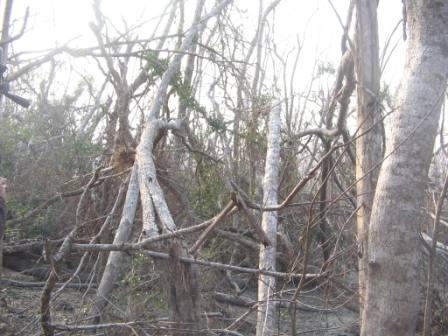
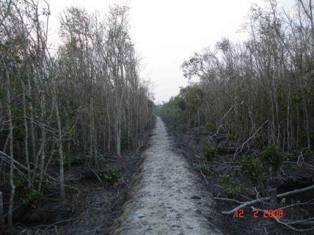
Sidr, with a ferocious wind force of over 220 kilometres per hour (kmph), hit the eastern parts of the forest, especially Chandpai range including Kochikhali, Kotka, Hiron Point, and Dublarchar, leaving a trail of severe devastation. The uprooted trees and destroyed houses on the edge of the forest are reminiscent of the devastation brought to the forest by the cyclone of 1988, sources said. In 1988, according to official records, nine tigers and several hundred deer perished when a six feet high tidal surge accompanied by 160 kmph wind hit the Sundarbans. Several newspapers published photographs of the corpses of deer, tigers and other wildlife. But the damage done to the forest by Sidr with its seven feet high tidal surge accompanied with a wind speed of over 220 kmph might be much worse than before. Some experts said they fear many wildlife including, tigers, deer, crocodiles, wild boars, king cobras, and monkeys might have been washed away and perished under the weight of uprooted trees of the world natural heritage site. Sidr practically ruined the beauty of the Sundarbans, the experts observed.
The storm eventually made landfall near Bangladesh on November 15. The name Sidr was contributed by Oman; it is an Arabic name of a tree belonging to the Ziziphus family, specifically the Ziziphus spina-christi.On mid-day of Wednesday 14th November, 2007 many people were evacuated to the cyclone shelters because of the cyclone warning of Bangladesh Meteorological Department. The Storm Centre of BMD in its bulletin forecasted that Cyclone Sidr would make landfall by noon. According to Mr. Farhad Ahmed of Disaster Management Bureau, when the people who took shelter saw that cyclone had still not come, they thought it would not materialize and left the cyclone shelters for their homes. Many of these people fell victim to the fury of the cyclone. BMD came under heavy criticism for having forecasted landfall ahead of time. However, according to Mr. Shah Alam, Deputy Director of Climate Division of BMD, the Cyclone Sidr reduced its speed before approaching coastal landmass and accordingly BMD on 15th revised its bulletin. It forecasted that Sidr would hit Bangladesh coastline on the same day in the evening between 6 and 10 PM . One thing has transpired from this fatal mistake of leaving the shelter early is that people should remain in the cyclone shelters until it has left the area. It is important that cyclone shelters should have the basic amenities so that people could stay there for few days. There should be adequate facilities for water, sanitation, sleeping space, generator lights, and paramedics at cyclone shelters. Provision must be made for food so that evacuees could have meals for at least two days either from their own sources or from the government. The government should deploy trucks, buses, inland vessels to evacuate people
to the cyclone shelters, Upajila and Thana headquarters and arrange for their return. This will encourage people to heed to cyclone warnings because at present warnings are often ignored because of the hassle to move to cyclone shelters and wrong alarms. There is necessity to develop good road networks in the coastal region for easy movement.
The government should make facilities for F.M. Radio broadcasts along the coast, which shall provide timely cyclone warning to coastal population.There is dearth of cyclone shelters in the coastal region. Those that have been constructed (2,500) after the 1987 cyclone have worn out and require either major repairs or reconstruction. In densely populated areas, there should be bigger shelters. Existing government and public assets such as office buildings educational institutions, places of prayers should also be renovated to be used as cyclone shelters Secondly, sea walls or cost effective earthen embankments along the coastline are good option to create defense against tidal bore. Sea walls will be equally effective against predicted sea level rise due to climate change. Instead of constructing sea walls entirely of concrete these could be made having concrete or brick lining on both sides with the hollow in the middle filled up by sand bags or just sand to make it a strong and effective barrier. At present, the low height embankments can hardly repulse a 10.6 meter (34.77 feet) high tidal bore like that of 1970. In coastal islands such as Hatiya, earthen embankments exist but they are not covered by trees to compensate their low height and sustain the impact of cyclone wind. Embankments could be constructed with the earth obtained from excavating large tanks in the coastal region. This will also meet the scarcity of fresh water immediately after a cyclone. Government should start a major programme for constructing embankments concrete, semi-concrete or plains earthen depending upon the degree of threat so that all inhabited coastal areas can be enclosed. In fact, even the Sunderbans forest requires embankments to protect its habitats of living species. Lives of many embankments have come to an end because some of them were constructed during Ayub Khan's time. Sidr has washed lot of embankments and they need to be reconstructed.
Sunderbun forest has saved many lives and destruction of property from the battering wind of Cyclone Sidr. Other options for protection includes extension of present Sunderban forest, which can help create a natural barrier against cyclone. Mangrove forest is very effective to dissipate the powerful force of waves. Once Sunderban forest extended up to Rajbari district in the North, (along the Padma river) and to the coastline of Patuakhlai district in the south east. During the British period, these areas were cleared for human habitation and cultivation. In the coastal islands and char areas along the coast, the government should bring all its khas lands under reforestation scheme. Emphasis should be given on thick vegetation from top to bottom. Coastal species of trees have mostly bare trunks, which make them unsuitable for facing combination of seawater and high velocity winds. Tall bamboo thickets can prove to be ideal for creating an impenetrable barrier. Cyclone wind is more destructive whenever there is open space. This could be sea fronts, watersheds, char lands, rivers, canals, paddy fields, water tanks, front or backyard of village homesteads. If we can encircle all these open spaces with thick forestation, the impact of wind can be lessened. Village people can be motivated to undertake voluntary efforts under community forest schemes. Cyclone Sidr caused heavy damage to village homes. Weak structures were smashed to
the ground. In coastal areas wider side of houses face the sea. The narrower side if faced seawards it can sustain far greater impact of wind. Moreover, they are built on mud platforms mainly by wooden frames. Instead low cost concrete
pre-fabricated pillars at least 4”x 4” on each side should be used to build houses. Each of the pillars should have a foundation of four to five feet deep. Roofs of houses should be built not on wooden frames rather on iron angle bars
so that tin sheets could be bolted rather than nailed. Wooden frames give away easily to powerful swirling winds. Government as well as NGO's should take the initiative to introduce these house-building materials for rural folks at a cost effective price. Interest free loans through co-operatives for reconstruction of homes could immensely help them.
There is an acute need for an integrated coastal zone management plan, not only to integrate cyclone preparedness and protection measures with the development plan of the area but also to give priority to such measures. We have seen the vulnerability of the coastal people to frequent cyclones.
Their ability to revive and stand up against natural calamities has become seriously compromised due to precarious condition of the coastal region.
Environmental degradation such as disappearance of mangrove forest, wanton felling of trees and wetland encroachments are causing ecological disaster making it more difficult to face threats from climate change. It is predicted that global warming will increase cyclones and they will become more powerful and harmful than the experienced ones. Western countries have moral responsibility for the consequences faced by the developing countries due to climate change and must come forward to reduce its effect. Bangladesh should make its concerns deeply felt before the international community so that international responses against climate change should complement the national measures to save the lives and livelihood of millions of people living in the coastal region.
Impact On People
Tidal waves reaching up to a height of 3 metres (9.8 ft) were reported in the north western coastal areas of Bangladesh, triggering panic among the fishing community.The damage in Bangladesh was extensive, including tin shacks flattened, houses and schools blown away and enormous tree damage. Some local officials have described the damage as being even
worse than that from the 1991 cyclone. The entire cities of Patuakhali, Barguna and Jhalokati District were hit hard by the storm surge of over 5 meters (16 ft). About a quarter of the world heritage site Sunderbans were damaged.
Researchers said mangrove forest Sunderban will take at least 40 years to recover itself from this catastrophe. Much of the capital city of Dhaka was also severely affected, as electricity and water service were cut and significant damage was reported there due to winds and flooding. The local agricultural industry was also devastated, as many rice crops - which have a December harvest were lost. At least 3,447 deaths have been reported. The one of the hardest-hit area was Bagerhat, where 610 people were reported to have been killed according to local officials. Patuakhali Barguna was also hard-hit, with 362 deaths reported. Most of the deaths confirmed thus far were due to the winds, although 13 of them have been as a result of capsized boats in the Faridpur district of Bangladesh. The head of the Red Crescent in Bangladesh expects the death toll to reach as high as 10,000. Over 3,000 other fishermen were reported missing on over 500 fishing boats.
Impact OnSundarbans
Sidr, with a ferocious wind force of over 220 kilometres per hour (kmph), hit the eastern parts of the forest, especially Chandpai range including Kochikhali, Kotka, Hiron Point, and Dublarchar, leaving a trail of severe devastation. The uprooted trees and destroyed houses on the edge of the forest are reminiscent of the devastation brought to the forest by the cyclone of 1988, sources said. In 1988, according to official records, nine tigers and several hundred deer perished when a six feet high tidal surge accompanied by 160 kmph wind hit the Sundarbans. Several newspapers published photographs of the corpses of deer, tigers and other wildlife. But the damage done to the forest by Sidr with its seven feet high tidal surge accompanied with a wind speed of over 220 kmph might be much worse than before. Some experts said they fear many wildlife including, tigers, deer, crocodiles, wild boars, king cobras, and monkeys might have been washed away and perished under the weight of uprooted trees of the world natural heritage site. Sidr practically ruined the beauty of the Sundarbans, the experts observed.
Sidr's impact on Sundarbans